Mapping Out Your Hunt
When I was growing up, picking a place to put your treestand is quite a bit different from what I go through now days. Because we didn’t have any portable stands, the search for the perfect location was usually about the search for a group of two or three trees that we could put up our permanent stands with 2 by 4’s and nails. Location wasn’t even in the thought process.
Today, picking a spot is all about location. And if the perfect setup isn’t quite right, what can be done by manipulating the habitat (fence jumps, food plots, interior plots and thickets, etc.). I want to focus on location with this piece and what I look for when using aerial photos to scout.

Farm 1 is about 200 acres and is a farm I hunted for several years but no longer hunt.
The google earth image above is from a farm I hunted for over a decade in western Wisconsin. The red outlines the approximate farm boundaries. When we first started hunting this farm, there was only one area that looking at the map stood out to me as a very solid stand location. It was S1, or the inside corner formed from the cow pasture to its north and west. Deer traveling through the timber in this area could do so randomly, but I have found that whenever you have large tracts of timber with an inside corner, that this corner pushes the deer into the area at the inside corner where the deer “wrap” around. Deer don’t like to cross open ground if they have another option available. Inside corners form a perfect ambush site. For S1, what I did was set my stand just inside the woods near the corner hunting it with a south or southeast wind. This took my scent out over the cow pasture where for the most part very few deer crossed. Most of the deer traveling back and forth through this area would compress down just inside this corner. Over the years, it proved to be one of the most reliable stand sites on this farm. Access was made possible by walking up the cow pasture in the bottom of the valley and into the stand. The blue line represents access in and out. What the map doesn’t show that you would only get by scouting on foot was that the cows came down into the woods from their pasture to water in springs. The cow pasture ran the entire length of our access walk making it easy and possible to enter quietly and under the disguise of cows. It worked beautifully.
Stand sites S2 and S3 were made possible because of habitat manipulations we did…which is for another piece.

Farm 2 is also a farm I used to hunt.
The map above is the other half of the same farm we hunted in western Wisconsin. A couple location sites stood out on this part of the farm. Let’s start with S2-the fence line. S2 is actually an outside corner…or really two outside corners if you look at it closely. Normally, I don’t like outside corners. But in this case, what you have are two tracts of timber, north and south, connected by a brushy fence line. Deer, especially bucks traveling during the rut, will use this fence line as a travel corridor preferring this crossing over bumbling out in the open to cross from tract to tract. Again, it proved to be an outstanding location. We hung our set on the southern tree line and hunted it with a west or southwest wind.
Then, there is S4-inside corner. S4 had a major flaw…can you guess it? Although S4 was an inside corner, and was actually an awesome spot, we had no way to access this location. If you look at where S4 is, our farm did not contain the open ground to its west. Therefore, our only access to S4 was through the timber which didn’t work because the deer would bed in this area. Going in to S4 meant bumping deer almost every time. We had to abandon it.
Now, S3 was the stand of all stands. You can see that S3 is situated in a funnel between two blocks of timber. It is narrow enough that a hunter can cover almost the whole funnel. We hung our stand inside the funnel on the south edge and hunted it with a north wind taking our scent over the farm fields to the south. Deer traveling east to west or west to east passed through the funnel and upwind of us. We added the food plot in later years to further enhance this location.
S5 is also an inside corner formed by the timber to the south, the funnel, and the timber to the north. Almost every deer traveling through this area would pass by S5. And again, what the map can’t show is that from S5 going east the terrain dropped off sharply into a deep ravine. By hunting this set with a west wind, it was almost impossible for any deer to scent you especially in the morning on a cold day as thermals were rising. S5 was simply a deadly setup during the rut. Can you see it?
There are a couple more inside corners on this farm, but, as you can see, the neighbors owned those inside corners. The bigger timber on the north side of this farm had tons of deer in it but made hunting hard because access was not so good. It seemed like the only time you could get away with walking into some of the stand we had in there were on windy mornings when you could sneak in undetected…otherwise your hunt would be over before it ever began.
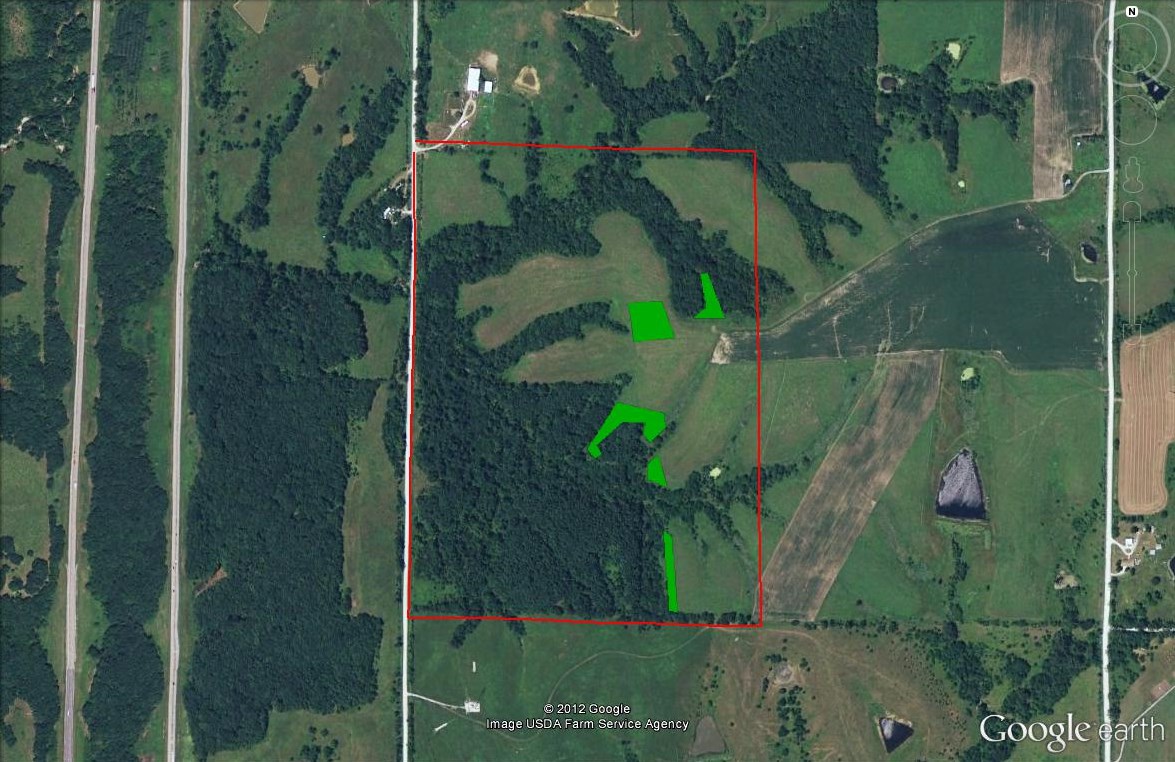
The map above is my farm in Iowa. The green shows the food plots I have strategically placed throughout the farm. Based on this map, can you see the obvious stand locations? I’ll give you some clues…look for fence lines, inside corners, funnels, and field crossing points. Can you see them?
Learning how to read a map to take an over the top view of your hunting area is a very efficient way to scout and hang stands. It doesn’t always work out as many times I have pointed to an area I would like to hunt based on an aerial photo only to get there on foot and realize it just doesn’t work. Swirling winds, lack of trees, no way to access the area, are some of the things that can make an otherwise perfect set up no so perfect anymore. Mapping out your hunting area is a very effective and efficient way to begin putting the pieces together on each new farm or area you hunt.